Overview of Bac Giang province
Views:
Bac Giang is a mountainous province in the Northeast region of the country with a total area of 3827.4 square kilometers. It has 9 districts and one city including 6 mountainous districts and a highland one and 230 communes, wards and towns.
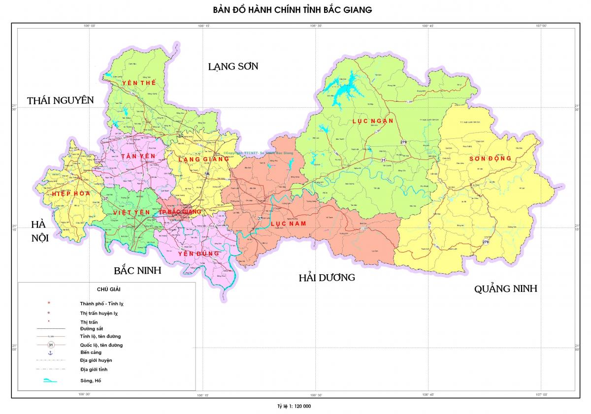
Administrative map of Bac Giang province (Source: bacgiang.gov.vn)
Bac Giang is a mountainous province in the Northeast region of the country with a total area of 3827.4 square kilometers. It has 9 districts and one city including 6 mountainous districts and a highland one and 230 communes, Ắc quy xe máy wards and towns.
1. Geography
Bac Giang province is located at the 21˚7’ to 21˚37’ North and 105˚53’ to 107˚ 2’ East. It’s borders Lang Son (Huu Lung district) province to the North and Northeast, Thai Nguyen province (Dong Hy district) to the West, Hanoi (Soc Son district) to the Southwest, Bac Ninh province (Cau river) and Hai Duong province (Chi Linh district) to the South and Quang Ninh province hoa phat (Dong Trieu district) to the East. Lying between the midland and mountainous areas to the north and the Red River Delta to the south , Bac Giang is on the economic corridor of Lang Son- Hanoi- Hai Phong- Quang Ninh and in Hanoi capital planned area which is 50 kilometers from Hanoi, 110 kilometers from Huu Nghi border gate (Lang Son province), 100 kilometers from Hai Phong port and 40 kilometers from Noi Bai international airport.
2. Terrain
The terrain is moderately mountainous (accounting for 72% of the total land area) alternated with delta land máy xay thịt làm giò chả area (accounting for 28% of the total land area). The elevation and inclination of the province decreases from the north to the south (down from around 500 meters to 100 meters compared to the sea level and about 20˚ to 0˚).
Mountainous terrain is mainly in Son Dong, Máy tăng âm truyền thanh Luc Ngan, Luc Nam districts featured with heavy fragmentation and height difference. Low mountainous areas are favorable to cultivate fruit and industrial trees like lychee, orange, grapefruit, custard-apple, soybeans and tea leaves, etc. and breed many kinds of livestock and poultry.
Midland and plain terrain is mainly found in Tan Yen, Hiep Hoa, Viet Yen, Yen Dung and Lang Giang districts and Bac Giang city. These areas are đau đầu suitable for food crops, fruit and industrial trees, livestock, poultry and aquatic product.
3. Climate
The province has the dominant Tinh dầu dừa characteristics of the tropical and temperate climate zone of the northeast area. The climate in the province has been discerned in four distinct seasons - the cold, dry season from November to January; the hot, rainy season from May to July; the warm, humid season from February to April; the temperate season from July to November.
The annual average humidity is reported to be 83%, of which humidity level in some months is over 85%. Humidity Ắc quy khô xe máy in dry season is in the range of 74% to 80%. The average rainfall is reported to be 1,553 millimeters, with highest rates from April to September. The annual sunny hours of 1,500 to 1,700 hours is good for tropical and subtropical tree cultivation.